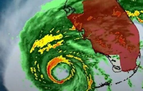
Powerful Hurricane Ian making landfall on Florida’s west coast today Loop Cayman Islands
Black Immigrant Daily News
Smith Road traffic signal remains down due to CUC line incident
Support seniors and Meals on Wheels on Dress Down Day, Friday, Sept 30
East End Heritage Day postponed
DEH operations resume after passage of hurricane Ian
Powerful Hurricane Ian making landfall on Florida’s west coast today
World Tourism Day: CHTA reflects on the future of Caribbean tourism
Riders and pedestrians wade through flooded road in the Philippines
Hurricane Ian to hit western Cuba at 125 mph, Category 3
Update: Tropical Depression Eleven forms
This is when government schools will reopen now that Ian has passed
Life-threatening storm surge, swells, heavy rain and dangerous flash flooding expected
20 hrs ago
Hurricane Ian
(image: The Weather Channel)
Hurricane Ian, currently west-south-west of Naples and reportedly displaying maximum sustained winds of 155 mph, is expected to make a powerful impact on the west coast of Florida today.
Based on the Saffir-Simpson Hurricane Wind Scale, the catastrophic damage to be left in the path of this mammoth category 4 hurricane is anticipated to include the following:
severe damage to homes, with loss of some roof structures and/or some exterior wallssnapped or uprooted treesdowned power lines and power outages for weeks or months in some areasdangerous storm surge, swells, flooding and possibly tornadoes in some places
This range of damage is still projected for the coastline and other areas inland even though Hurricane Ian is predicted to get weaker once it makes its first landfall somewhere around Sarasota, Naples and Fort Myers, Florida.
Hurricane Ian storm surge forecast (Image: The Weather Channel)
As a result of the life-threatening dangers, all interests on Florida’s west coast and inland are encouraged to stay vigilant, take precautions and adhere to official evacuation or other notices from local authorities.
Similar precautions apply to Charleston and Charlotte, where a second landfall is expected by Thursday evening. This projected, second landfall, is shown below.
Hurricane Ian projected second landfall (image: The Weather Channel)
As a result of the foregoing, the National Hurricane Center advised of the below warnings and watches in place as of Wednesday morning:
A Hurricane Warning is in effect for:
Chokoloskee to Anclote River, including Tampa BayDry Tortugas
A Storm Surge Warning is in effect for:
Suwannee River southward to FlamingoTampa BayLower Florida Keys from Big Pine Key westward to Key WestDry TortugasFlagler/Volusia Line to the mouth of the St. Mary’s RiverSt. Johns River
A Tropical Storm Warning is in effect for:
Cuban provinces of La Habana, Mayabeque, and MatanzasIndian Pass to the Anclote RiverAll of the Florida KeysFlamingo to South Santee RiverFlamingo to ChokoloskeeLake OkeechobeeFlorida BayBimini and Grand Bahama Islands
A Storm Surge Watch is in effect for:
Florida Keys from the Card Sound Bridge westward to east of Big Pine KeyFlorida BayMouth of St. Mary’s River to South Santee River
More From
Life-threatening storm surge, swells, heavy rain and dangerous flash flooding expected
The East End Heritage Committee is postponing its Heritage Day on Friday, 30 September to allow for Hurricane Ian debris clearance from Heritage Day Field.
The Pirates Fest event will be reschedul
The National Roads Authority (NRA) is advising members of the public that the traffic signal at the junction of Smith Road and Bobby Thompson Way remains down.
According to Edward Howard, the NRA’s
Hurricane Ian tore into western Cuba as a major hurricane Tuesday and left 1 million people without electricity, then churned on a collision course with Florida over warm Gulf waters amid expectations
Leanni Tibbetts has been crowned Miss World Cayman Islands 2022.
Tibbetts, who was contestant #1, also won Miss Photogenic, Miss Best on Sports, Miss Best Island Couture and Miss Best in Interview
NewsAmericasNow.com


Leave a Reply
Want to join the discussion?Feel free to contribute!